Hurricane Beryl Map Shows Path Shifting Toward Texas


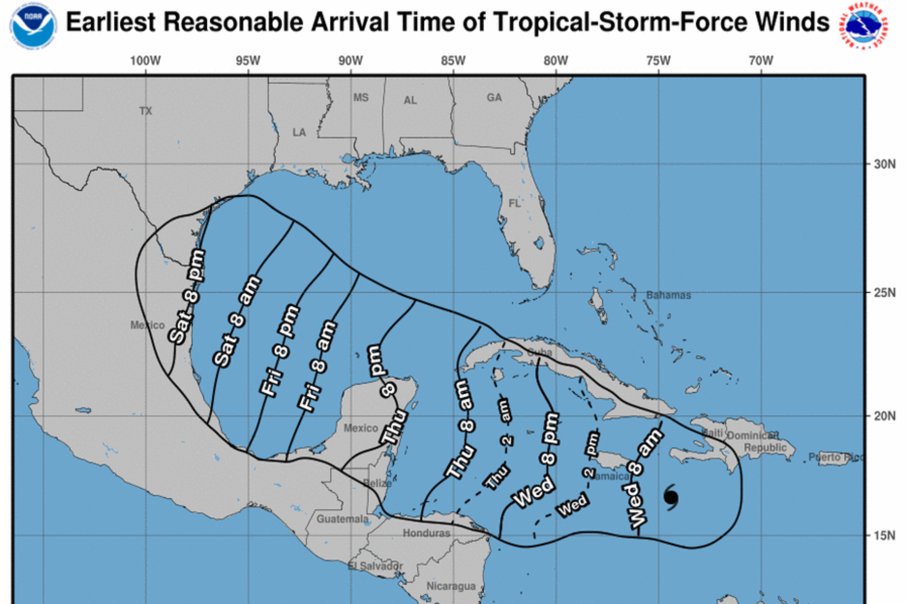
The most-recent National Hurricane Center (NHC) forecast shows winds related to Hurricane Beryl arriving in Texas on Saturday night.
Beryl strengthened into a hurricane on Saturday, becoming June’s easternmost major hurricane in the Atlantic. The storm underwent rapid intensification and became a Category 4 hurricane as soon as its wind speeds reached 130 miles per hour. The system temporarily weakened to a Category 3 before strengthening again, with maximum winds documented at 150 mph when it made landfall in the Windward Islands on Monday morning.
At one point, Hurricane Beryl was categorized as a Category 5, but it has since weakened again to a Category 4, with wind speeds at 145 mph.
The storm continues to tear through the Caribbean, and the NHC expects it to arrive in Jamaica on Wednesday afternoon. It will continue its progress toward the Cayman Islands and arrive there early on Thursday.
“Devastating hurricane-force winds, life-threatening storm surge, and damaging waves are expected,” the most-recent warning said. “Life-threatening flash flooding and mudslides from heavy rainfall are expected over much of Jamaica and southern Haiti through today.”
Forecasters had anticipated that Beryl’s track would take the storm south of Texas, but the updated forecast shows tropical storm-force winds arriving in the state by Saturday night.
“Beryl is forecast to remain a hurricane when it approaches the Yucatán Peninsula and Belize late Thursday, where hurricane and tropical storm watches have been issued,” the NHC said. “There remains uncertainty in the track and intensity forecast of Beryl over the Western Gulf of Mexico this weekend. Interest in the Western Gulf of Mexico should monitor the progress of Beryl.”
Beryl is the first hurricane of the 2024 Atlantic hurricane season and the second named storm. Tropical Storm Alberto made landfall in Mexico on the morning of June 20. Shortly after Beryl formed, the third named storm of the season—Tropical Storm Chris—formed quickly on Sunday night. Chris made landfall in Mexico on Sunday night, with wind speeds at around 40 mph. It has since dissolved.
Multiple agencies, including the National Oceanic and Atmospheric Administration, have issued forecasts warning that 2024 will be an exceptionally strong year for hurricanes.
NOAA’s forecast anticipates 17 to 25 named storms for an above-average hurricane season. Of the 25, eight to 13 will be hurricanes, and four to seven will be major hurricanes. The forecast number of named storms, hurricanes, and major hurricanes is the highest NOAA has ever issued in a May outlook.
Several factors are contributing to this year’s storm-heavy predictions, including abnormally warm sea surface temperatures and the expectation that El Nino will transition into La Nina by this summer or fall.
Newsweek is committed to challenging conventional wisdom and finding connections in the search for common ground.
Newsweek is committed to challenging conventional wisdom and finding connections in the search for common ground.
The post Hurricane Beryl Map Shows Path Shifting Toward Texas appeared first on Newsweek.